
Earth’s forests grew 9% in a new satellite survey
Posted: June 1, 2017Source: Sciencemag.org
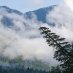 The Age of Exploration may be long past, but even in the 21st century, our maps can still get a major update. Using satellite imagery, a new study has found hidden forests all over the world—almost enough for a second Amazon—in areas with little moisture known as drylands. Past estimates of how much of the world’s drylands are covered in forests have run into lots of problems: For instance, the satellite images used to measure them are often so low-resolution that it’s hard to figure out the difference between a tree, a shadow, or even a patch of dirt. To correct for that, an international team of researchers performed the first global study using a new set of ultra–high–resolution Google Earth images—in which each pixel represents a patch of ground less than a meter wide, as opposed to tens of meters. Hundreds of scientists and students then combed through 210,000 images and found that the world’s drylands host 40% more forests than thought, the team writes today in Science. That’s more than a 9% bump in total global forest coverage, or two-thirds the size of the Amazon.
Hidden forests
A new study using high-definition satellite images has found 378 million additional hectares of hidden forests around the globe—almost enough for a second Amazon.
The study will help researchers figure out how best to conserve and restore these forested areas. It will also help scientists make more accurate estimates of how much carbon dioxide Earth’s trees are sucking out of the atmosphere—and how much of our fossil fuel emissions they’ll be able to handle in the future.