Wilderness areas are a laboratory for fire scientists, managers
Posted: August 7, 2017Source: Treesource by
Fitz fire escaping the White Cap study area Credit: BobMutch
The helicopter circled over a small fire in the Frank Church-River of No Return Wilderness, near the border between Idaho and Montana. It was the summer of 2013 and Dave Campbell, the U.S. Forest Service district ranger responsible for the wilderness, peered down, trying to decide how far the fire would spread.
Based on his observations of hundreds of fires in the area, he believed it would probably burn down a hill and stall out on the banks of the Selway River. The computer models backed up his prediction, so Campbell decided to let it burn.
“But what we didn’t predict was that the next week the temperatures would be hitting almost the triple digits,” said Campbell who is now retired. “The humidities would be way low for a solid week and then the fire behavior became a much bigger deal.”
The fire moved down the hill to the river, and jumped it, crossing the state line into Montana. What Campbell originally expected to be a 15,000-acre fire in an isolated wilderness area became the Gold Pan fire, burning more than 40,000 acres and threatening several campgrounds and a historic cabin.
It took weeks to suppress the fire, and before it was over, the chief of a rural fire district near the burn area wrote to his congressman calling for Campbell’s dismissal.
“The Wilderness Act clearly says you should allow the fire to burn,” Campbell said. “But there are many wildernesses that are small, or in such close proximity to values at risk, that they really can’t afford to do that. That really makes it difficult.”
For decades, the U.S. Forest Service has used wilderness areas as a laboratory to learn more about wildfire behavior and its effects. Scientists have found that a hands-off approach can reduce fuel loads and restore ecosystems.
Land managers have started to apply some of those lessons to managing fires outside of the wilderness, but letting fires burn inevitably puts valuable resources at risk and many people living near forests are uncomfortable with letting fires get too close.
Now, fire managers must weigh the benefits of letting a fire burn with the damage it might cause, or the backlash it might generate.
For many years, the Forest Service’s wildland firefighting policy was simple: Extinguish them all. In 1910, catastrophic forest fires in Idaho and Montana burned millions of acres of forest and killed more than 80 people in just two days. The so-called “Big Burn” had a profound effect on the agency’s approach to fire management.
Starting in 1935, the Forest Service aimed to put out all fires the morning after they were spotted, a policy known as the 10 a.m. rule. But in 1964, Congress passed the Wilderness Act to set aside land where natural forces would be allowed to prevail. That included fire.
In 1970, the Forest Service started the White Cap Project, an experiment allowing fire to burn in the wilderness. In 1972, John McGuire, then chief of the Forest Service, signed an order allowing the first wildfire to burn near Bad Luck Creek in the Selway-Bitterroot Wilderness of western Montana.
Bob Mutch conducted much of the field research leading to the implementation of the White Cap Project and briefed McGuire on the plan about a week before that first fire. He was collecting data in the Selway-Bitterroot with his daughter Linda when he got a call on the radio.
“We got this air patrol message that there was this lightning fire that had just started in a ponderosa pine-Douglas fir (stand),” Mutch said. “They wanted me to go in and look at it before they made the decision to allow it to burn.”
Mutch hiked down to a cabin, and the next morning a helicopter brought him to the site of the fire. It was small. He watched it for a while, determined it probably wouldn’t spread, and radioed his report in to dispatch. The agency let it burn. Four days later, the fire died out of its own accord.
“Perhaps this is a good first fire,” Match wrote afterward in his journal. “It is the kind of quiet fire we need for a time or two to bring people along and make them feel comfortable with fire management.”
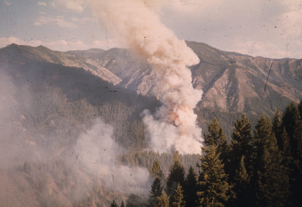
The Bad Luck fire eased the Forest Service into a new era of fire management, but the very next year a larger blaze put the agency’s resolve to the test. The Fritz Creek fire ignited inside the White Cap study area of the Selway-Bitterroot Wilderness on August 10, 1973. By the end of the month, it had grown to more than 1,000 acres and had escaped the study area.
Mutch watched from a lookout tower as the fire burned up a slope and out of the management area. He worried the size of the fire would make the forest supervisor flinch. But Orville Daniels — then supervisor of the Bitterroot National Forest — allowed it to burn, suppressing only the portion of the fire that had left the study area.
Since those first two fires, land managers have observed fires in the wilderness to help them decide when to put them out and when to let them burn. Campbell, the former district ranger who decided to let the Gold Pan fire burn in 2013, made that decision more than 300 times in his career. He said watching fires in the Selway-Bitterroot Wilderness gave him the confidence to stay out of the way.
“The only way you can really know how to predict how a fire’s going to burn is if you’ve watched one burn previously,” Campbell said. “And if everyone you have stomp out, you never know what might have happened.”
That’s the basis for fire scientist Carol Miller’s research at the Aldo Leopold Wilderness Institute in Missoula, Montana. In a 2015 paper published in Ecological Applications, she mapped out fires from 1972 to 2012 in four different wilderness areas across the West — including the Selway-Bitterroot — and found that in many cases, old fires limit the spread of new fires.
“We’ve gone and looked at where fires interacted, looked at statistically is there evidence that the previous fire inhibited the growth of the subsequent fire,” Miller said.
She also looked at the role of weather and topography. “With enough data, you can tease apart the statistical results there and say whether each of those factors was important or not.”
The burn areas on Miller’s map fit together like a giant jigsaw puzzle, with new fires following the edges of old burn areas. It’s not a perfect puzzle, and Miller says there are some caveats. The effect lasts between six and 18 years, depending on the study area, and hot, dry weather can override it.
But the pattern is clear: Fires can reduce fuel loads and prevent other fires from spreading.
“We’ve quantified how long that lasts, under what weather conditions it holds up, how it interacts with topography,” Miller said. “Managers can take that information and say, ‘This burn scar that’s 15 years old is still going to hold up under these conditions.’ ”
However, Miller acknowledged that even armed with that knowledge it can be hard for managers to justify letting fires get close to populated areas.
She said if managers can’t let fire in, prescribed burns and physically removing fuel can do some of that work. But she warned that those strategies only work on a small scale, whereas natural fires can burn hundreds of thousands of acres.
**
Andrew Larson, a scientist at the University of Montana, agreed that prescribed fire and mechanical treatments can be a partial substitute for natural fires, and said he wants to see prescribed fire used more often.
But he argued that forest managers may need to go even further. In a 2013 paper published in Ecological Applications, he showed that following decades of fire suppression, one fire may not be enough to restore a forest to its previous state.
At his study site in the Bob Marshall Wilderness, a preliminary fire in 2003 reduced tree density but also stimulated the growth of lodgepole pines. It wasn’t until a second fire in 2011 that the forest returned to a stable state.
“When you’ve had 50 to 100 years of forest growth … you can’t recover from that with just one wildfire,” Larson said. “Fires consume fuel but they also kill trees, which then translates to more fuel. So it really takes two or even three fires to bring the fuel loads back down.”
Studying fires in the wilderness and watching them burn helps managers decide how to act, but as that information filters down to the general public it also becomes easier for them to make that decision. Larson said he feels like most fire managers have a good understanding of the science. At this point, he’s more concerned about communicating with the public.
“One of the things I advocate very strongly for is trying to help managers and the public change our relationship, some of our core assumptions and understandings about fire,” Larson said.
It’s a challenge Dave Campbell understands well, not only through his experience as a district ranger but also because his house on the eastern edge of the Bitterroot National Forest nearly burned down in a large fire in the summer of 2016.
“My neighborhood is pretty black right now. I mean, there’s a lot of burned trees, and I’m not particularly crazy about that,” Campbell said. “I lost some big 200-year-old ponderosa pines, but I know in the long-term frame of things that’s happened before.”
He said nobody would have chosen to let that fire burn because of how close it was to people’s homes. But as the wall of flames approached his house, he watched with a mixture of concern and curiosity.
He walked around the porch dousing embers with a fire hose, switching to buckets of water from his hot tub when the power went out. Eventually, he left, but he wanted to stay and watch.
When Dave Campbell smells smoke, he said it takes him back to his summers fighting fires as an 18-year-old. He remembers making overtime wages, drinking beer, and having a good time. That’s why he can look at a wall of flames approaching his house with interest. He’s learned to think of fire as an integral part of the forest.
He said that part of the reason many people fear fire is that they only see the dramatic images of forest fires that make it on the front page of the newspaper.
As a district ranger, he set up webcams so people could see forest fires burn day-to-day, and always tried to keep roads open during fires so that people could watch them. He felt like allowing people to see forest fires in person might change public understanding and attitudes and might make it easier for managers to allow them to burn.